Storm Damage in The Albany Area 2/17/2006
4pm Update: The NWS in Albany, NY is confirming a measured wind gust of 143 MPH this afternoon in Stratton, VT at the ski resort. The NWS called the ski resort who has a full weather station at the top of the mountain (at 3880 feet), and they confirmed the measurement. Amazing.
-----------------------------------------------------------------
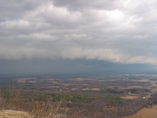
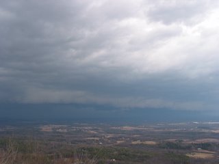
I just got back from a storm chase in Albany, which, until today, was unheard of for the month of February. I noticed that the line of convection earlier this morning was becoming even more linear and read numerous reports of wind speeds of 50-60mph with gusts as high as 75mph in Western and Central New York. So, I decided to take a ride up to John Boyd Thacher State Park with camera in hand to witness the gust front and some high winds first hand. Shortly after arriving there I received notification that Severe Thunderstorm Warnings had been issued for many counties in my area. Cool. To the west I could see a nice gust front/shelf cloud moving in. You can see the pictures below.
As the gust front neared, I heard what sounded like a roar (think freight train description of a tornado for those in Tornado Alley) and realized it was the wind gusting up and closing in on me. As I snapped more pictured the wind gusted to about 60 mph (estimated) many times and I found myself catching my balance. (I also found myself getting in my SUV and backing it away from the cliff that was 20 feet away :) Lol. As the front moved through the temperature dropped from about 52 degrees at 10:10am to 35 degrees at 10:29am. Unbelievable temperature swing behind the front!! Also, I witness a lightning flash in the area of Colonie as the heaviest part of the storm affected those areas. The rain quickly changed to moderate sleet with a little bit of snow. I have never seen wind driven sleet fall in sheets this hard and this fast. It was hurting my face and hands. In any case, it was quite a spectacle to see. As I descended the mountain the sleet and slow lessened and turned back to rain.
NWS reports are impressive with this event. Apparently there is major damage in the majority of the counties in Central New York. At least 1 fatality has already been reported. Here are some of the reports courtesy of the NWS:
Lowville, NY: 81 mph (BARN COLLAPSED)
Rochester, NY: 77 mph
Fairfield, NY: 73 mph
Schenectady AP, NY: 63 mph
Saratoga AP, NY: 67 mph
Albany, NY: 60 mph
Middleburgh, NY: 71 mph
North Adams, MA: 58 mph
Fulton/Montgomery County: Trees/power line down countywide
Herkimer County: Trees on Houses/Roof Damage throughout County/Barn Blown Down
Central NY: Power line and many utility poles themselves are down.


-----------------------------------------------------------------
I just got back from a storm chase in Albany, which, until today, was unheard of for the month of February. I noticed that the line of convection earlier this morning was becoming even more linear and read numerous reports of wind speeds of 50-60mph with gusts as high as 75mph in Western and Central New York. So, I decided to take a ride up to John Boyd Thacher State Park with camera in hand to witness the gust front and some high winds first hand. Shortly after arriving there I received notification that Severe Thunderstorm Warnings had been issued for many counties in my area. Cool. To the west I could see a nice gust front/shelf cloud moving in. You can see the pictures below.
As the gust front neared, I heard what sounded like a roar (think freight train description of a tornado for those in Tornado Alley) and realized it was the wind gusting up and closing in on me. As I snapped more pictured the wind gusted to about 60 mph (estimated) many times and I found myself catching my balance. (I also found myself getting in my SUV and backing it away from the cliff that was 20 feet away :) Lol. As the front moved through the temperature dropped from about 52 degrees at 10:10am to 35 degrees at 10:29am. Unbelievable temperature swing behind the front!! Also, I witness a lightning flash in the area of Colonie as the heaviest part of the storm affected those areas. The rain quickly changed to moderate sleet with a little bit of snow. I have never seen wind driven sleet fall in sheets this hard and this fast. It was hurting my face and hands. In any case, it was quite a spectacle to see. As I descended the mountain the sleet and slow lessened and turned back to rain.
NWS reports are impressive with this event. Apparently there is major damage in the majority of the counties in Central New York. At least 1 fatality has already been reported. Here are some of the reports courtesy of the NWS:
Lowville, NY: 81 mph (BARN COLLAPSED)
Rochester, NY: 77 mph
Fairfield, NY: 73 mph
Schenectady AP, NY: 63 mph
Saratoga AP, NY: 67 mph
Albany, NY: 60 mph
Middleburgh, NY: 71 mph
North Adams, MA: 58 mph
Fulton/Montgomery County: Trees/power line down countywide
Herkimer County: Trees on Houses/Roof Damage throughout County/Barn Blown Down
Central NY: Power line and many utility poles themselves are down.


posted by Howard Altschule at 2/17/2006 11:15:00 AM
0 comments
![]()
![]()
